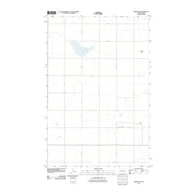
2011 Map of Grass Lake
USGS Topo · Published 2011About this map
Grass Lake serves as a central geographical landmark in this Burleigh County landscape, surrounded by a surveyed grid of rural roads. The settlement of Still sits along the eastern edge of the quadrangle, reflecting the sparse, organized development of the North Dakota plains. The agricultural character of the region is punctuated by specialized landmarks like the Erickson Landing Strip, which hints at the logistical needs of remote farming operations. Evidence of the area's local heritage is preserved at the Mission Free Cemetery, located along 318th Ave NE. The road network, including 80th St NE and 52nd St NE, demonstrates the systematic Section Line road layout typical of the Midwest, providing a clear view of how land was partitioned and accessed in the early twenty-first century.
Find a feature on this map
18 named features on this map. Tap any name to fly to it.
Don’t see what you’re looking for? This feature index may not catch every label — zoom into the map to look around manually.
Map Details
Editions of this 2011 Grass Lake Map
This is the sole edition of this map. No revisions or reprints were ever made.
Other maps of this area

1949 · Turtle Creek
USGS Topo · 1:62,500

1950 · Wilton
USGS Topo · 1:62,500

1954 · McClusky
USGS Topo · 1:250,000

1958 · McClusky
USGS Topo · 1:250,000

1959 · Mercer SW
USGS Topo · 1:24,000

1959 · Mercer SE
USGS Topo · 1:24,000

1961 · Turtle Creek SE
USGS Topo · 1:24,000

1966 · Wilton SE
USGS Topo · 1:24,000
1966 · Wilton
USGS Topo · 1:24,000
1975 · Regan SE
USGS Topo · 1:24,000