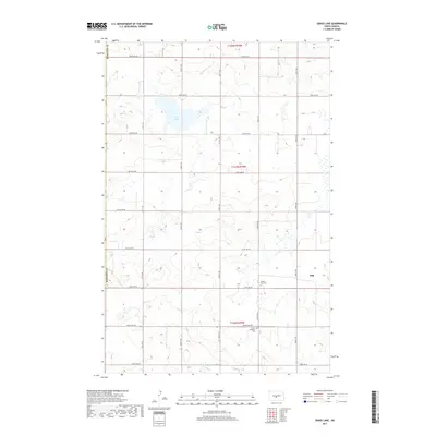
2017 Map of Grass Lake
USGS Topo · Published 2017About this map
The tiny settlement of Still anchors the eastern edge of this Burleigh County prairie, where a grid of rural section roads divides a landscape defined by seasonal wetlands and glacial potholes. The topography is dominated by Grass Lake, a significant water body in the northern half of the quadrangle, while the southern reaches are drained by the meandering W Br Apple Cr. This map documents a quiet agricultural region with deep community roots, most notably represented by the Sunne Lutheran Cem and Mission Free Cem. These cemetery sites, along with the sparse remaining structures near Still, offer essential coordinates for genealogists tracing Norwegian-American families and early homesteaders in the Northern Plains. The intricate contour lines reveal the subtle, undulating drainage patterns of the Missouri Plateau, showing how water and transportation corridors shaped the development of these rural townships.
Find a feature on this map
20 named features on this map. Tap any name to fly to it.
Don’t see what you’re looking for? This feature index may not catch every label — zoom into the map to look around manually.
Map Details
Editions of this 2017 Grass Lake Map
This is the sole edition of this map. No revisions or reprints were ever made.
Other maps of this area

1949 · Turtle Creek
USGS Topo · 1:62,500

1950 · Wilton
USGS Topo · 1:62,500

1954 · McClusky
USGS Topo · 1:250,000

1958 · McClusky
USGS Topo · 1:250,000

1959 · Mercer SW
USGS Topo · 1:24,000

1959 · Mercer SE
USGS Topo · 1:24,000

1961 · Turtle Creek SE
USGS Topo · 1:24,000

1966 · Wilton SE
USGS Topo · 1:24,000
1966 · Wilton
USGS Topo · 1:24,000
1975 · Regan SE
USGS Topo · 1:24,000