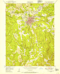
1949 Map of Grass Valley
USGS Topo · Published 1954About this map
Gold mining operations define the landscape surrounding Grass Valley in the late 1940s, with a dense network of shafts and tailings ponds concentrated east and south of the town center. Extensive industrial footprints like the Empire Mine and Idaho-Maryland Mine sit alongside smaller operations such as the North Star Mine and Ophir Hill Mine. The town's social fabric is visible through landmarks like the Hennessey Sch, St Marys Cem, and Grass Valley Memorial Hospital.
Find a feature on this map
76 named features on this map. Tap any name to fly to it.
Don’t see what you’re looking for? This feature index may not catch every label — zoom into the map to look around manually.
Map Details
Editions of this 1949 Grass Valley Map
3 editions found
Other maps of this area

1888 · Smartsville
USGS Topo · 1:125,000

1891 · Colfax
USGS Topo · 1:125,000

1891 · Smartsville
USGS Topo · 1:125,000

1892 · Smartsville
USGS Topo · 1:125,000

1892 · Colfax
USGS Topo · 1:125,000

1894 · Colfax
USGS Topo · 1:125,000

1894 · Smartsville
USGS Topo · 1:125,000

1895 · Smartsville
USGS Topo · 1:125,000

1898 · Colfax
USGS Topo · 1:125,000

1900 · Colfax
USGS Topo · 1:125,000