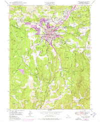
1949 Map of Grass Valley
USGS Topo · Published 1976About this map
Grass Valley and its surrounding gold-bearing terrain dominate this postwar landscape, updated to show the expanding footprint of the 1970s. The map highlights a massive network of industrial legacies, from the sprawling Empire Mine and North Star Mine to the complex operations at the Idaho-Maryland Mine. These workings, many identified with their specific shafts and tailings ponds like those near Ophir Hill, reflect the deep-rooted mining economy of Nevada County. Small settlements and specialized locations such as Town Talk, Boston Ravine, and La Barr Meadows are joined by the Nevada County Memorial Hospital and Mt St Marys Acad, anchoring the civic life of the region. The landscape is also defined by essential water infrastructure, including the Rough and Ready Ditch and numerous reservoirs like Grass Valley Res, which historically fed both the mines and the agricultural properties like Stockdale Ranch.
Find a feature on this map
69 named features on this map. Tap any name to fly to it.
Don’t see what you’re looking for? This feature index may not catch every label — zoom into the map to look around manually.
Map Details
Editions of this 1949 Grass Valley Map
3 editions found
Other maps of this area

1888 · Smartsville
USGS Topo · 1:125,000

1891 · Colfax
USGS Topo · 1:125,000

1891 · Smartsville
USGS Topo · 1:125,000

1892 · Smartsville
USGS Topo · 1:125,000

1892 · Colfax
USGS Topo · 1:125,000

1894 · Colfax
USGS Topo · 1:125,000

1894 · Smartsville
USGS Topo · 1:125,000

1895 · Smartsville
USGS Topo · 1:125,000

1898 · Colfax
USGS Topo · 1:125,000

1900 · Colfax
USGS Topo · 1:125,000