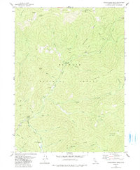
1979 Map of Grasshopper Ridge
USGS Topo · Published 1991About this map
Klamath National Forest dominates this topographic study of the Siskiyou mountains, revealing a landscape defined by its mining and timber history. Near the center of the quadrangle, Georges Ranch and its nearby Cem suggest early settlement patterns, while the Deacon Timber Camp (Site) and Moccasin Ranch (Site) mark locations of former operations. The terrain is deeply incised by a complex drainage network where the South Fork Salmon River and East Fork Salmon River converge, fed by numerous named gulches like Gooey Gulch and Gibson Gulch. Evidence of high-country resource extraction is visible through labels for Mines, Dry Gulch Mines, and Dredge Tailings along the creeks. From the heights of Grasshopper Ridge and the Eddy Gulch Lookout, several springs including Campbell Spring and Maple Spring provide vital water sources for the remote backcountry.
Find a feature on this map
43 named features on this map. Tap any name to fly to it.
Don’t see what you’re looking for? This feature index may not catch every label — zoom into the map to look around manually.
Map Details
Editions of this 1979 Grasshopper Ridge Map
2 editions found
Other maps of this area

1886 · Shasta
USGS Topo · 1:250,000

1894 · Shasta
USGS Topo · 1:250,000

1923 · Sawyers Bar
USGS Topo · 1:125,000

1931 · Etna
USGS Topo · 1:96,000

1934 · Etna
USGS Topo · 1:125,000

1948 · Weed
USGS Topo · 1:250,000

1950 · Weed
USGS Topo · 1:250,000

1955 · Cecilville
USGS Topo · 1:62,500

1955 · Sawyers Bar
USGS Topo · 1:62,500

1955 · Etna
USGS Topo · 1:62,500