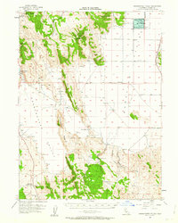
1954 Map of Grasshopper Valley
USGS Topo · Published 1963About this map
Grasshopper Valley and the surrounding high basins of Lassen County are defined here by a network of seasonal water sources and livestock infrastructure. The landscape transition from the volcanic heights of Whitinger Mountain down to the Dry Valley floor is marked by numerous vital landmarks for the mid-century ranching economy, including Monroe Corrals and several isolated outposts like Sylvia and McCoy Flat. The presence of the Pacific Southern rail line along the eastern edge of the Madeline Plains Waterfowl Management Area highlights the area's role as a transit corridor for the region's timber and cattle.
Find a feature on this map
35 named features on this map. Tap any name to fly to it.
Don’t see what you’re looking for? This feature index may not catch every label — zoom into the map to look around manually.
Map Details
Editions of this 1954 Grasshopper Valley Map
3 editions found
Other maps of this area

1886 · Alturas
USGS Topo · 1:250,000

1886 · Honey Lake
USGS Topo · 1:250,000

1891 · Honey Lake
USGS Topo · 1:250,000

1892 · Alturas
USGS Topo · 1:250,000

1893 · Honey Lake
USGS Topo · 1:250,000

1954 · Karlo
USGS Topo · 1:62,500

1954 · Grasshopper Valley
USGS Topo · 1:62,500

1954 · Ravendale
USGS Topo · 1:62,500

1954 · Fredonyer Peak
USGS Topo · 1:62,500

1954 · Alturas
USGS Topo · 1:250,000