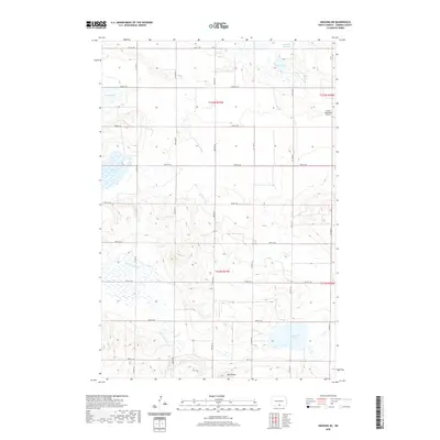
2020 Map of Grassna NE
USGS Topo · Published 2020About this map
Volk Butte rises as a prominent landmark in this corner of Emmons County, overlooking a landscape defined by glacial depressions and seasonal wetlands. The northern reaches of the quadrangle are dotted with numerous basins, including Maier Lake, Heidrich Slough, and Kremer Lake, which illustrate the typical pothole geology of the North Dakota plains. The drainage of Little Beaver Cr cuts through the western sections, while the southeastern corner is marked by Schwahn Lake. Human infrastructure is characterized by a precise grid of rural section-line roads, such as 81st St SE and 89th St SE, which facilitate access to the agricultural tracts. Near the eastern boundary, the presence of the Linton Municipal Airport indicates the regional significance of this area for local transportation and civil aviation, serving the community just beyond the map's edge.
Find a feature on this map
21 named features on this map. Tap any name to fly to it.
Don’t see what you’re looking for? This feature index may not catch every label — zoom into the map to look around manually.
Map Details
Editions of this 2020 Grassna NE Map
This is the sole edition of this map. No revisions or reprints were ever made.
Other maps of this area

1954 · Bismarck
USGS Topo · 1:250,000

1958 · Bismarck
USGS Topo · 1:250,000

1971 · Grassna NW
USGS Topo · 1:24,000
1971 · Kiefer Buttes
USGS Topo · 1:24,000
1971 · Grassna
USGS Topo · 1:24,000

1971 · Hazelton SW
USGS Topo · 1:24,000

1971 · Grassna NE
USGS Topo · 1:24,000

1971 · Strasburg
USGS Topo · 1:24,000

1971 · Temvik
USGS Topo · 1:24,000
1979 · Westfield
USGS Topo · 1:24,000