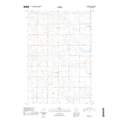
2020 Map of Grassna NW
USGS Topo · Published 2020About this map
Saint Bernard Catholic Cem anchors the southern portion of this Emmons County landscape, providing a primary point of interest for genealogists and local historians. The terrain is defined by a complex network of seasonal water bodies and perennial streams, most notably Beaver Creek in the north and the winding Little Beaver Cr further south. These waterways are interspersed with numerous depressions typical of the regional topography, including Schumacher Slough, Walther Slough, and Berreth Lake. A strictly gridded road system, including Main Ave and various numbered streets like 81st St SW, delineates the land into regular sections, reflecting the enduring legacy of the Public Land Survey System. The map documents the persistent agricultural character of the area, where water management and cemetery preservation remain central to the community's spatial organization.
Find a feature on this map
29 named features on this map. Tap any name to fly to it.
Don’t see what you’re looking for? This feature index may not catch every label — zoom into the map to look around manually.
Map Details
Editions of this 2020 Grassna NW Map
This is the sole edition of this map. No revisions or reprints were ever made.
Other maps of this area

1954 · Bismarck
USGS Topo · 1:250,000

1958 · Bismarck
USGS Topo · 1:250,000

1968 · Cannon Ball SE
USGS Topo · 1:24,000

1968 · Fort Yates SE
USGS Topo · 1:24,000

1968 · Fort Yates NE
USGS Topo · 1:24,000

1971 · Grassna NW
USGS Topo · 1:24,000
1971 · Kiefer Buttes
USGS Topo · 1:24,000
1971 · Grassna
USGS Topo · 1:24,000

1971 · Hazelton SW
USGS Topo · 1:24,000

1971 · Grassna NE
USGS Topo · 1:24,000