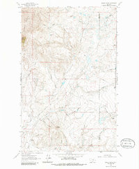
1962 Map of Grassy Butte
USGS Topo · Published 1986About this map
High plains ranching and rugged topography dominate this early 1960s landscape along the border of Toole and Liberty Counties. Notable landmarks such as Middle Butte and Gold Butte rise above a complex network of seasonal drainages, including Strawberry Creek and the curiously named Grandma Coulee. The map captures the remote operations of the T C Morris Ranch and Purnell Ranch, connected by primitive trails and the winding Strawberry Road. The emergence of modern energy infrastructure is evident through several Gas Wells and an extensive aboveground pipeline system that cuts across the coulees. This survey provides a precise record of water sources critical to the region's cattle operations, from Chicago Lake to the mineral-rich Alkali Spring.
Find a feature on this map
34 named features on this map. Tap any name to fly to it.
Don’t see what you’re looking for? This feature index may not catch every label — zoom into the map to look around manually.
Map Details
Editions of this 1962 Grassy Butte Map
2 editions found

Other maps of this area

1954 · Shelby
USGS Topo · 1:250,000

1958 · Shelby
USGS Topo · 1:250,000

1962 · Whitlash
USGS Topo · 1:24,000

1962 · Cameron Lake
USGS Topo · 1:24,000

1962 · Hawthorne School
USGS Topo · 1:24,000

1962 · Berkholder Reservoir
USGS Topo · 1:24,000

1962 · Blair Ranch
USGS Topo · 1:24,000

1962 · Fey Lakes
USGS Topo · 1:24,000
1962 · Hawley Hill
USGS Topo · 1:24,000

1962 · Haystack Butte
USGS Topo · 1:24,000