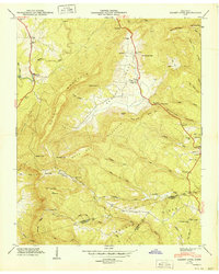
1949 Map of Grassy Cove
USGS Topo · Published 1949About this map
The remarkable karst landscape of Grassy Cove dominates this Tennessee Valley Authority study, showing a large enclosed valley where drainage disappears into limestone sinks. The map details a rural mountain economy at the end of the 1940s, centered on small settlements like Linary and Jewett and the winding Alvin C York Highway. The terrain is defined by the massive flanks of Brady Mountain and Walden Ridge, which hem in the cultivated valley floors. Genealogists can locate several family burial grounds, including Reed Cem and Hinch Cem, alongside community landmarks like Alloway Ch and Alloway Sch. This era captures the area before modern development, preserving the locations of numerous mountain gaps and hollows, such as Stillhouse Hollow and Low Gap, and the specific placements of Mill Cave and Saltpeter Cave that hint at the region's unique geology.
Find a feature on this map
79 named features on this map. Tap any name to fly to it.
Don’t see what you’re looking for? This feature index may not catch every label — zoom into the map to look around manually.
Map Details
Editions of this 1949 Grassy Cove Map
This is the sole edition of this map. No revisions or reprints were ever made.
Other maps of this area

1887 · Kingston
USGS Topo · 1:125,000

1891 · Kingston
USGS Topo · 1:125,000

1892 · Pikeville
USGS Topo · 1:125,000

1893 · Kingston
USGS Topo · 1:125,000

1895 · Pikeville
USGS Topo · 1:125,000

1909 · Sequatchie Valley
USGS Topo · 1:62,500

1910 · Pikeville
USGS Topo · 1:62,500

1912 · Crossville
USGS Topo · 1:62,500

1935 · Melvine
USGS Topo · 1:24,000

1935 · Pennine
USGS Topo · 1:24,000