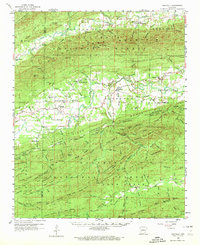
1960 Map of Gravelly
USGS Topo · Published 1972About this map
Ouachita National Forest dominates this landscape along the border of Scott and Yell Counties, where the rugged topography of the Fourche River and La Fave River valleys defined rural life in the mid-20th century. Local communities like Gravelly, Bluffton, and Briggsville are shown during a period of established agricultural and timber activity, connected by the early alignments of state routes. Genealogists will find significant value in the documentation of several family and community burial grounds, including Egypt Cemetery near Blue Ball and Mt Pleasant Cemetery north of Waitreak. The map captures the social hubs of the era, such as the Fourche Valley School and churches like Mulberry Church. The terrain is characterized by named ridges and peaks such as Ganders Peak and Bogus Ridge, illustrating the isolated valleys that shaped the settlement patterns of this region.
Find a feature on this map
135 named features on this map. Tap any name to fly to it.
Don’t see what you’re looking for? This feature index may not catch every label — zoom into the map to look around manually.
Map Details
Editions of this 1960 Gravelly Map
3 editions found

Other maps of this area

1879 · Mountain Home
USGS Topo · 1:62,500

1887 · Magazine Mountain #4
USGS Topo · 1:62,500

1887 · Mount Ida #2
USGS Topo · 1:62,500

1887 · Magazine Mountain #3
USGS Topo · 1:62,500

1887 · Magazine Mountain
USGS Topo · 1:62,500

1888 · Dardanelle #3
USGS Topo · 1:62,500

1890 · Magazine Mountain
USGS Topo · 1:125,000

1890 · Mount Ida
USGS Topo · 1:125,000

1890 · Hot Springs
USGS Topo · 1:125,000

1890 · Dardanelle
USGS Topo · 1:125,000