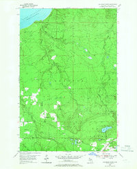
1954 Map of Graveraet River
USGS Topo · Published 1967About this map
Lake Superior shoreline and the heavily forested interior of Houghton County define this mid-century portrait of the Keweenaw Peninsula. The landscape is marked by the complex drainage systems of the Graveraet River and the Salmon Trout River, which cut through the townships of Stanton and Adams. In the southern portion of the map, the small settlement of Toivola serves as a local hub, anchored by the Toivola Cem and the Finnish Ch.
Find a feature on this map
21 named features on this map. Tap any name to fly to it.
Don’t see what you’re looking for? This feature index may not catch every label — zoom into the map to look around manually.
Map Details
Editions of this 1954 Graveraet River Map
Other maps of this area

1915 · Houghton
USGS Topo · 1:62,500

1946 · South Range
USGS Topo · 1:24,000

1948 · South Range
USGS Topo · 1:24,000

1954 · Graveraet River
USGS Topo · 1:24,000

1954 · Oskar
USGS Topo · 1:24,000

1954 · Beacon Hill
USGS Topo · 1:24,000

1954 · Rockhouse Point
USGS Topo · 1:24,000

1954 · Pelkie
USGS Topo · 1:62,500

1954 · Winona
USGS Topo · 1:62,500

1954 · Houghton
USGS Topo · 1:62,500