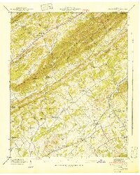
1941 Map of Graveston
USGS Topo · Published 1941About this map
Beard Comb, Buffalo Ridge, and Copper Ridge dominate the landscape in this 1941 survey of the borderlands between Union and Knox Counties. The settlement at Corryton serves as a local hub along the Southern railroad, while the eponymous Graveston is marked by the Graveston Mill Pond along Flat Creek. This era of East Tennessee is defined by a dense network of family cemeteries and community centers, including Old Flat Creek Cem, Ailor Cem, and Sharp Cem, reflecting generations of local lineage.
Find a feature on this map
51 named features on this map. Tap any name to fly to it.
Don’t see what you’re looking for? This feature index may not catch every label — zoom into the map to look around manually.
Map Details
Editions of this 1941 Graveston Map
2 editions found
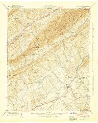
Other maps of this area

1897 · Maynardville
USGS Topo · 1:125,000

1900 · Maynardville
USGS Topo · 1:125,000

1935 · Luttrell
USGS Topo · 1:24,000

1935 · Mascot
USGS Topo · 1:24,000

1935 · Straw Plains
USGS Topo · 1:48,000

1935 · Graveston
USGS Topo · 1:24,000

1935 · Fountain City
USGS Topo · 1:24,000

1936 · Gorryton
USGS Topo · 1:48,000

1936 · Powder Springs
USGS Topo · 1:24,000

1936 · White Hollow
USGS Topo · 1:24,000