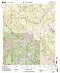
2004 Map of Graveyard Canyon
USGS Topo · Published 2006About this map
The Sacramento Mountains define this high-altitude landscape in southern New Mexico, where the Sacramento River carves its way through the canyon floor. The community of Timberon serves as a primary point of interest, featuring the Timberon Lodge and a nearby airstrip. This era of the region’s development is characterized by a mix of forestry, ranching, and military use, with a significant portion of the land designated as the Fort Bliss Military Reservation (McGregor Range) and the Lincoln National Forest. Longstanding agricultural history is evident in the presence of Fairchild Ranch, Circle Cross Ranch, and Moss Ranch. Local infrastructure includes a network of trails such as the Rim Trail and Spiller Canyon Trail, alongside water management features like the aqueduct and various tanks. A small Cem and the Herman Monument offer specific points for genealogical and local history research.
Find a feature on this map
64 named features on this map. Tap any name to fly to it.
Don’t see what you’re looking for? This feature index may not catch every label — zoom into the map to look around manually.
Map Details
Editions of this 2004 Graveyard Canyon Map
This is the sole edition of this map. No revisions or reprints were ever made.
Other maps of this area

1950 · Escondido Canyon
USGS Topo · 1:62,500

1950 · Alamogordo
USGS Topo · 1:62,500

1952 · Cloudcroft
USGS Topo · 1:62,500

1954 · Carlsbad
USGS Topo · 1:250,000

1958 · Carlsbad
USGS Topo · 1:250,000

1965 · Bear Spring
USGS Topo · 1:24,000

1965 · Surveyors Canyon
USGS Topo · 1:24,000

1965 · Rogers Ruins
USGS Topo · 1:24,000

1965 · El Paso Canyon
USGS Topo · 1:24,000
1974 · Sacramento
USGS Topo · 1:24,000