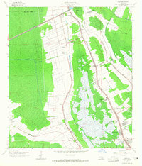
1963 Map of Gray
USGS Topo · Published 1965About this map
The low-lying wetlands of Bayou Country are defined here by a transition from industrial activity to deep southern plantation heritage. The corridor of Bayou Terrebonne and Bayou Blue serves as the primary artery for settlement, where communities like Gray and Schriever are clustered along the high ground. Large agricultural estates including Magnolia Plantation, Minerva Plantation, and Rebecca Plantation dominate the western landscape, intersected by the Southern Pacific railroad lines.
Find a feature on this map
53 named features on this map. Tap any name to fly to it.
Don’t see what you’re looking for? This feature index may not catch every label — zoom into the map to look around manually.
Map Details
Editions of this 1963 Gray Map
4 editions found
Other maps of this area

1892 · Lac Des Allemands
USGS Topo · 1:62,500

1892 · Gibson
USGS Topo · 1:62,500

1892 · Houma
USGS Topo · 1:62,500

1892 · Thibodaux
USGS Topo · 1:62,500

1897 · Gibson
USGS Topo · 1:62,500

1932 · Lac Des Allemands SW
USGS Topo · 1:31,680

1932 · Houma SW
USGS Topo · 1:31,680

1932 · Houma NW
USGS Topo · 1:31,680

1932 · Thibodaux SE
USGS Topo · 1:31,680

1932 · Thibodaux SW
USGS Topo · 1:31,680