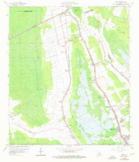
1963 Map of Gray
USGS Topo · Published 1976About this map
Sugar cane cultivation and the petroleum industry define the landscape between Schriever and Gray during the early 1960s. The map illustrates the transition from traditional agricultural tracts like Magnolia Plantation, Minerva Plantation, and Rebecca Plantation toward more diverse land use, including the Lafourche Crossing Oil and Gas Field. The corridor is anchored by the Southern Pacific railroad and the winding course of Bayou Terrebonne, which historically dictated the pattern of settlement and transport in this part of Lafourche and Terrebonne Parishes. Social and community life are well-documented through landmarks such as St Bridget Ch, the Garden of Memories Cem, and the Price Sch. Emerging mid-century local culture is represented by the Radio Station (KGIL) and a Drive-in Theater, providing a detailed look at the infrastructure supporting these growing rural communities.
Find a feature on this map
50 named features on this map. Tap any name to fly to it.
Don’t see what you’re looking for? This feature index may not catch every label — zoom into the map to look around manually.
Map Details
Editions of this 1963 Gray Map
4 editions found
Other maps of this area

1892 · Lac Des Allemands
USGS Topo · 1:62,500

1892 · Gibson
USGS Topo · 1:62,500

1892 · Houma
USGS Topo · 1:62,500

1892 · Thibodaux
USGS Topo · 1:62,500

1897 · Gibson
USGS Topo · 1:62,500

1932 · Lac Des Allemands SW
USGS Topo · 1:31,680

1932 · Houma SW
USGS Topo · 1:31,680

1932 · Houma NW
USGS Topo · 1:31,680

1932 · Thibodaux SE
USGS Topo · 1:31,680

1932 · Thibodaux SW
USGS Topo · 1:31,680