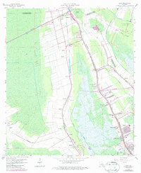
1963 Map of Gray
USGS Topo · Published 1986About this map
The low-lying wetlands of Lafourche and Terrebonne Parishes are defined by a complex network of waterways, where the Southern Pacific railroad and early highways follow the narrow natural levees. Large-scale agricultural operations including Magnolia Plantation, Minerva Plantation, and Rebecca Plantation demonstrate the historical reliance on these higher ground strips for settlement and farming. Along the corridor between Schriever and Gray, the landscape is dotted with community centers such as St Bridget Ch, St Marks Ch, and the Evergreen Jr High Sch, reflecting the established cultural geography of the mid-20th century. To the south and east, the transition into the marsh is marked by Devil Swamp and the Oil and Gas Field, highlighting the region's move toward petroleum extraction alongside its traditional plantation economy. Many family-named landmarks and cemeteries like Garden of Memories Cem and Halfway Cem provide significant detail for genealogical research in these coastal parishes.
Find a feature on this map
59 named features on this map. Tap any name to fly to it.
Don’t see what you’re looking for? This feature index may not catch every label — zoom into the map to look around manually.
Map Details
Editions of this 1963 Gray Map
4 editions found
Other maps of this area

1892 · Lac Des Allemands
USGS Topo · 1:62,500

1892 · Gibson
USGS Topo · 1:62,500

1892 · Houma
USGS Topo · 1:62,500

1892 · Thibodaux
USGS Topo · 1:62,500

1897 · Gibson
USGS Topo · 1:62,500

1932 · Lac Des Allemands SW
USGS Topo · 1:31,680

1932 · Houma SW
USGS Topo · 1:31,680

1932 · Houma NW
USGS Topo · 1:31,680

1932 · Thibodaux SE
USGS Topo · 1:31,680

1932 · Thibodaux SW
USGS Topo · 1:31,680