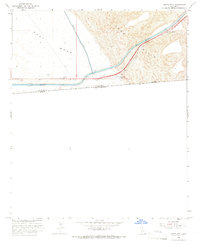
1964 Map of Grays Well
USGS Topo · Published 1972About this map
The international boundary between United States and Mexico defines the southern edge of this desert survey, where engineering marvels meet the shifting geography of the Sand Hills. The All American Canal and Coachella Canal are the primary features of the landscape, tracing a blue path through the arid East Mesa. These waterways represent the mid-century agricultural lifeline of the Imperial Valley, with Drop 1 marking a specific point of irrigation management along the route. Human activity is sparse but concentrated along the transit corridors, noted by the Grays Well Site and Gordons Well. These locations, along with a Roadside Rest, highlight the survival of early desert travelers and the evolution of modern highway infrastructure through Imperial County.
Find a feature on this map
13 named features on this map. Tap any name to fly to it.
Don’t see what you’re looking for? This feature index may not catch every label — zoom into the map to look around manually.
Map Details
Editions of this 1964 Grays Well Map
2 editions found
Other maps of this area

1903 · Yuma
USGS Topo · 1:125,000

1905 · Yuma
USGS Topo · 1:125,000

1907 · Holtville
USGS Topo · 1:125,000

1942 · El Centro
USGS Topo · 1:250,000

1942 · Yuma
USGS Topo · 1:250,000

1953 · Grays Well
USGS Topo · 1:24,000

1953 · Ogilby
USGS Topo · 1:62,500

1953 · Cactus
USGS Topo · 1:24,000
1953 · Grays Well NE
USGS Topo · 1:24,000

1954 · El Centro
USGS Topo · 1:250,000