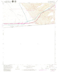
1964 Map of Grays Well
USGS Topo · Published 1979About this map
Algodones Dunes and the shifting terrain of the Sand Hills dominate this portion of the Colorado Desert along the international border. The landscape is defined by the vital water infrastructure of the All American Canal and the Coachella Canal, which cut through the arid East Mesa. These engineering feats represent the mid-century transformation of the region, bringing water to the imperial valley while navigating the difficult dune topography. Small outposts and historical markers like Gordons Well and the Grays Well (Site) indicate early desert travel routes and the importance of reliable water sources. The map also captures the northern edge of the United States Mexico boundary, flanked by a primitive Jeep Trail that skirts the Imperial Sand Hills Recreation Lands. This area also includes a portion of the Yuma Proving Ground, reflecting the military's use of the desert's isolation for testing and training.
Find a feature on this map
16 named features on this map. Tap any name to fly to it.
Don’t see what you’re looking for? This feature index may not catch every label — zoom into the map to look around manually.
Map Details
Editions of this 1964 Grays Well Map
2 editions found
Other maps of this area

1903 · Yuma
USGS Topo · 1:125,000

1905 · Yuma
USGS Topo · 1:125,000

1907 · Holtville
USGS Topo · 1:125,000

1942 · El Centro
USGS Topo · 1:250,000

1942 · Yuma
USGS Topo · 1:250,000

1953 · Grays Well
USGS Topo · 1:24,000

1953 · Ogilby
USGS Topo · 1:62,500

1953 · Cactus
USGS Topo · 1:24,000
1953 · Grays Well NE
USGS Topo · 1:24,000

1954 · El Centro
USGS Topo · 1:250,000