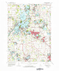
1960 Map of Grayslake
USGS Topo · Published 1965About this map
Chain O'Lakes State Park dominates the northwest quadrant of this survey, illustrating the complex hydrology of northeastern Illinois before modern suburban expansion fully integrated these lakeside communities. The region is defined by a dense network of interconnected waterways, including Fox Lake, Grass Lake, and Pistakee Lake, which served as the foundation for numerous recreational settlements such as Lotus Woods and Ingleside Shore. For genealogists, the map preserves the locations of rural landmarks like the English Prairie Cem and several family-named schools including Hooper Sch and Oakland Sch. The transport infrastructure of the mid-1960s is anchored by the Chicago Milwaukee St Paul and Pacific railroad, which links established towns like Antioch, Grayslake, and Lake Villa, showing the transition from a resort-focused economy to a permanent residential landscape.
Find a feature on this map
145 named features on this map. Tap any name to fly to it.
Don’t see what you’re looking for? This feature index may not catch every label — zoom into the map to look around manually.
Map Details
Editions of this 1960 Grayslake Map
This is the sole edition of this map. No revisions or reprints were ever made.
Other maps of this area

1892 · Racine
USGS Topo · 1:62,500

1893 · Silver Lake
USGS Topo · 1:62,500

1893 · Geneva
USGS Topo · 1:62,500

1900 · Highwood
USGS Topo · 1:62,500

1904 · Lake Geneva
USGS Topo · 1:62,500

1905 · Racine
USGS Topo · 1:62,500

1906 · Silver Lake
USGS Topo · 1:62,500

1906 · Lake Geneva
USGS Topo · 1:62,500

1906 · Waukegan
USGS Topo · 1:62,500

1908 · Waukegan
USGS Topo · 1:62,500