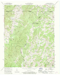
1959 Map of Grayson
USGS Topo · Published 1969About this map
Jefferson National Forest and Cherokee National Forest converge on this 1959 survey, where the rugged borders of Tennessee, Virginia, and North Carolina meet at a complex junction of ridges and hollows. The Norfolk and Western line winds through the northern terrain, passing the settlement of Taylors Valley and the Walnut Grove Ch. The landscape is a mix of high-altitude peaks like McQueen Knob and industrial activity, evidenced by strip mines located near Sugar Creek and Boiling Spring. Genealogists will find a high density of family burial grounds and landmarks, including Blevins Cem, Sutherland Cem, and the uniquely named Burnt School Cem. The map captures the remote character of these mountain communities at the end of the 1950s, centered around local gathering points like the Farmers Store and Mountain View Church.
Find a feature on this map
136 named features on this map. Tap any name to fly to it.
Don’t see what you’re looking for? This feature index may not catch every label — zoom into the map to look around manually.
Map Details
Editions of this 1959 Grayson Map
3 editions found

Other maps of this area

1891 · Abingdon
USGS Topo · 1:125,000

1893 · Cranberry
USGS Topo · 1:125,000

1894 · Abingdon
USGS Topo · 1:125,000

1895 · Cranberry
USGS Topo · 1:125,000

1899 · Cranberry
USGS Topo · 1:125,000

1902 · Cranberry
USGS Topo · 1:125,000

1909 · Abingdon
USGS Topo · 1:96,000

1911 · Abingdon
USGS Topo · 1:125,000

1935 · Konnarock
USGS Topo · 1:24,000

1935 · Grayson
USGS Topo · 1:24,000