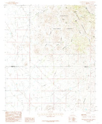
1985 Map of Greasewood Mountain
USGS Topo · Published 1985About this map
Greasewood Mountain anchors this high-desert landscape in the Pinaleno Mountains during the mid-1980s. The terrain is defined by a network of drainage systems and isolated water sources, including Frog Spring, Walnut Spring, and the Apache Reservoir. A significant portion of the northern area is managed as part of the Coronado National Forest, illustrating the transition between protected federal lands and the open range.
Find a feature on this map
25 named features on this map. Tap any name to fly to it.
Don’t see what you’re looking for? This feature index may not catch every label — zoom into the map to look around manually.
Map Details
Editions of this 1985 Greasewood Mountain Map
This is the sole edition of this map. No revisions or reprints were ever made.
Other maps of this area

1922 · Willcox
USGS Topo · 1:125,000

1942 · Mt. Graham
USGS Topo · 1:62,500

1943 · Willcox
USGS Topo · 1:62,500

1944 · Fisher Hills
USGS Topo · 1:62,500

1945 · Mt. Graham
USGS Topo · 1:62,500

1954 · Silver City
USGS Topo · 1:250,000

1957 · Luzena
USGS Topo · 1:62,500

1958 · Silver City
USGS Topo · 1:250,000

1958 · Willcox
USGS Topo · 1:62,500

1962 · Silver City
USGS Topo · 1:250,000