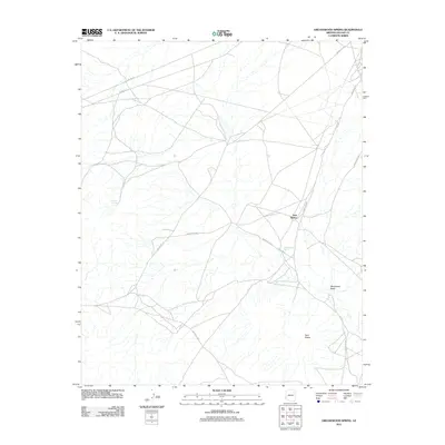
2011 Map of Greasewood Spring
USGS Topo · Published 2011About this map
Greasewood Spring and Martinez Spring serve as critical hydrological anchors in this high-desert landscape within the Navajo Nation. This 2011 survey illustrates a sparse but intentional network of infrastructure, where arterial roads like Indian Rte 15 and Indian Rte 153 intersect with localized routes such as Indian Rte 9004. The drainage patterns of Steamboat Wash define the local topography, punctuated by the distinct elevations of Twin Buttes in the eastern and central portions of the quadrangle. The map also documents the industrial presence of Gasline Rd, highlighting the intersection of traditional land use and modern utility corridors in the Fort Defiance Agency region.
Find a feature on this map
12 named features on this map. Tap any name to fly to it.
Don’t see what you’re looking for? This feature index may not catch every label — zoom into the map to look around manually.
Map Details
Editions of this 2011 Greasewood Spring Map
This is the sole edition of this map. No revisions or reprints were ever made.
Other maps of this area
1883 · Tusayan
USGS Topo · 1:250,000
1886 · Tusayan
USGS Topo · 1:250,000
1886 · Fort Defiance
USGS Topo · 1:250,000
1892 · Fort Defiance
USGS Topo · 1:250,000
1947 · Flagstaff
USGS Topo · 1:250,000
1954 · Flagstaff
USGS Topo · 1:250,000

1954 · Gallup
USGS Topo · 1:250,000

1958 · Gallup
USGS Topo · 1:250,000
1958 · Flagstaff
USGS Topo · 1:250,000

1959 · Gallup
USGS Topo · 1:250,000