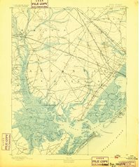
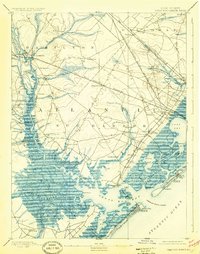
1893 Map of Great Egg Harbor
USGS Topo · Published 1899About this map
Mays Landing and the tidal reaches of the Great Egg Harbor River define this coastal landscape at the end of the nineteenth century. The map captures a critical era for the Atlantic County mainland, where traditional maritime landings like Scull Landing and Gibson Landing operate alongside a rapidly expanding rail network. The Philadelphia and Reading Railroad and the Camden and Atlantic Railroad cut across the wetlands toward the coast, signaling the region's shift toward the burgeoning resort economy. Inland, the landscape is dotted with small hamlets such as Bargaintown, Linwood, and Steelmansville, while industries like Doughty Mill and the Fish Factory near Longport reflect the era's reliance on local natural resources. The inclusion of multiple Life Saving Stations along the shore underscores the period's maritime hazards before modern navigation was established.
Find a feature on this map
104 named features on this map. Tap any name to fly to it.
Don’t see what you’re looking for? This feature index may not catch every label — zoom into the map to look around manually.
Map Details
Editions of this 1893 Great Egg Harbor Map
5 editions found


Other maps of this area

1884 · Sea Isle
USGS Topo · 1:62,500

1887 · Atlantic City
USGS Topo · 1:62,500

1888 · Dennisville
USGS Topo · 1:62,500

1888 · Little Egg Harbor
USGS Topo · 1:62,500

1888 · Sea Isle
USGS Topo · 1:62,500

1890 · Great Egg Harbor
USGS Topo · 1:62,500

1890 · Hammonton
USGS Topo · 1:62,500

1890 · Tuckahoe
USGS Topo · 1:62,500

1890 · Mullica
USGS Topo · 1:62,500

1893 · Great Egg Harbor
USGS Topo · 1:62,500