
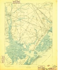
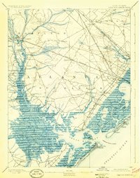
1893 Map of Great Egg Harbor
USGS Topo · Published 1918About this map
Mays Landing sits at the head of the Great Egg Harbor River, serving as a critical navigation point where the river transitions from a narrow waterway into the expansive marshes of the coast. The landscape is defined by an intricate network of tidal thorofares and creeks, such as Patcong Creek and English Creek, which supported numerous small maritime landings like Scull Landing and Jeffries Landing. Along the coast, the early development of Ocean City and South Atlantic City is visible, linked to the mainland by the West Jersey Railroad. A Fish Factory and several Life Saving Stations highlight the era's reliance on coastal industries and maritime safety. The inland terrain is characterized by dispersed settlements such as Bargaintown and Steelmansville, connected by a web of wagon roads and the Philadelphia and Reading Railroad, illustrating the late nineteenth-century transition from river-based transit to rail-dominated commerce.
Find a feature on this map
98 named features on this map. Tap any name to fly to it.
Don’t see what you’re looking for? This feature index may not catch every label — zoom into the map to look around manually.
Map Details
Editions of this 1893 Great Egg Harbor Map
5 editions found

Other maps of this area

1884 · Sea Isle
USGS Topo · 1:62,500

1887 · Atlantic City
USGS Topo · 1:62,500

1888 · Dennisville
USGS Topo · 1:62,500

1888 · Little Egg Harbor
USGS Topo · 1:62,500

1888 · Sea Isle
USGS Topo · 1:62,500

1890 · Great Egg Harbor
USGS Topo · 1:62,500

1890 · Hammonton
USGS Topo · 1:62,500

1890 · Tuckahoe
USGS Topo · 1:62,500

1890 · Mullica
USGS Topo · 1:62,500

1893 · Great Egg Harbor
USGS Topo · 1:62,500