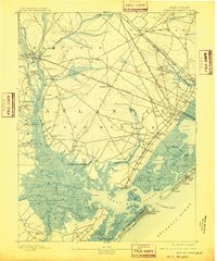
1893 Map of Great Egg Harbor
USGS Topo · Published 1910About this map
Mays Landing stands as a central hub in this late 19th-century survey of the New Jersey coast, where the Great Egg Harbor River snakes through dense marshlands toward the sea. The map reveals an intricate network of landings and small settlements, such as Wilson Landing, Thompsontown, and English Creek Landing, illustrating a riverside economy reliant on waterborne transport and local mills like Doughty Mill. To the east, the landscape transitions into the complex tidal geography of Lake Bay and Scull Bay, punctuated by maritime infrastructure including Life Saving Station (29) and a Fish Factory. The arrival of the modern era is marked by the intersecting routes of the Philadelphia and Reading Railroad and the West Jersey Railroad, which began to transform these traditional fishing and farming communities into the transit corridors of the early 20th century.
Find a feature on this map
102 named features on this map. Tap any name to fly to it.
Don’t see what you’re looking for? This feature index may not catch every label — zoom into the map to look around manually.
Map Details
Editions of this 1893 Great Egg Harbor Map
5 editions found
Other maps of this area

1884 · Sea Isle
USGS Topo · 1:62,500

1887 · Atlantic City
USGS Topo · 1:62,500

1888 · Dennisville
USGS Topo · 1:62,500

1888 · Little Egg Harbor
USGS Topo · 1:62,500

1888 · Sea Isle
USGS Topo · 1:62,500

1890 · Great Egg Harbor
USGS Topo · 1:62,500

1890 · Hammonton
USGS Topo · 1:62,500

1890 · Tuckahoe
USGS Topo · 1:62,500

1890 · Mullica
USGS Topo · 1:62,500

1893 · Great Egg Harbor
USGS Topo · 1:62,500