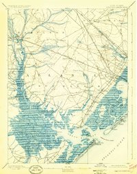
1893 Map of Great Egg Harbor
USGS Topo · Published 1925About this map
Mays Landing serves as a focal point at the head of the Great Egg Harbor River, where the transition from inland pine barrens to the intricate coastal wetlands begins. This late 19th-century survey by C.C. Vermeule documents a maritime landscape defined by tidal thoroughfares, salt marshes, and early coastal expansion. The intricate network of waterways like Patcong Creek and Scull Bay supported a economy of landings and small mills, such as Doughty Mill, while the coastal strip shows the early development of Ocean City and Somers Point. The inland reaches are characterized by family-named settlements like McKeetown and Risleyville, connected by a rapidly growing railroad infrastructure. The inclusion of maritime landmarks like the Fish Factory and Life Saving Station (30) reflects the vital connection between the mainland and the shifting sands of Risley Beach.
Find a feature on this map
104 named features on this map. Tap any name to fly to it.
Don’t see what you’re looking for? This feature index may not catch every label — zoom into the map to look around manually.
Map Details
Editions of this 1893 Great Egg Harbor Map
5 editions found
Other maps of this area

1884 · Sea Isle
USGS Topo · 1:62,500

1887 · Atlantic City
USGS Topo · 1:62,500

1888 · Dennisville
USGS Topo · 1:62,500

1888 · Little Egg Harbor
USGS Topo · 1:62,500

1888 · Sea Isle
USGS Topo · 1:62,500

1890 · Great Egg Harbor
USGS Topo · 1:62,500

1890 · Hammonton
USGS Topo · 1:62,500

1890 · Tuckahoe
USGS Topo · 1:62,500

1890 · Mullica
USGS Topo · 1:62,500

1893 · Great Egg Harbor
USGS Topo · 1:62,500