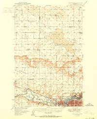
1951 Map of Great Falls
USGS Topo · Published 1951About this map
Great Falls is the industrial and transport hub of this mid-century landscape, positioned at the critical junction where the Missouri River meets the Great Sun River. The map illustrates a thriving post-war community supported by the Great Northern and the Chicago Milwaukee St Paul and Pacific railroads. Significant industrial activity is evident through the Oil Refinery and numerous Gravel Pits, while the presence of institutions like Columbus Hospital and multiple neighborhood schools—including McKinley Sch and Whittier Sch—points to a maturing urban center.
Find a feature on this map
44 named features on this map. Tap any name to fly to it.
Don’t see what you’re looking for? This feature index may not catch every label — zoom into the map to look around manually.
Map Details
Editions of this 1951 Great Falls Map
2 editions found

Other maps of this area

1886 · Great Falls
USGS Topo · 1:250,000

1948 · Portage
USGS Topo · 1:62,500

1949 · Portage
USGS Topo · 1:62,500

1949 · Cascade
USGS Topo · 1:62,500

1949 · Timber Coulee
USGS Topo · 1:62,500

1949 · Great Falls
USGS Topo · 1:62,500

1949 · Vaughn
USGS Topo · 1:62,500

1950 · Timber Coulee
USGS Topo · 1:62,500

1950 · Dent Bridge
USGS Topo · 1:62,500

1950 · Dutton
USGS Topo · 1:62,500