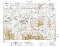
1954 Map of Great Falls
USGS Topo · Published 1974About this map
The Missouri River and Sun River converge at Great Falls, serving as the industrial and logistical anchor for this mid-century Montana landscape. Hydroelectric development is evident along the river's descent at Rainbow Dam and Cochrane Dam, while the sprawling Malmstrom Air Force Base highlights the era's military footprint east of the city. The surrounding plains are defined by extensive benchlands, such as the Greenfield Bench and Truly Bench, which support a network of small agricultural settlements and rail stops like Dutton, Fairfield, and Geraldine.
Find a feature on this map
154 named features on this map. Tap any name to fly to it.
Don’t see what you’re looking for? This feature index may not catch every label — zoom into the map to look around manually.
Map Details
Editions of this 1954 Great Falls Map
4 editions found

Other maps of this area

1886 · Great Falls
USGS Topo · 1:250,000

1886 · Fort Logan
USGS Topo · 1:250,000

1886 · Little Belt Mts.
USGS Topo · 1:250,000

1889 · Big Snowy Mountain
USGS Topo · 1:250,000

1889 · Helena
USGS Topo · 1:250,000

1890 · Fort Benton
USGS Topo · 1:250,000

1892 · Fort Benton
USGS Topo · 1:250,000

1893 · Helena
USGS Topo · 1:250,000

1893 · Big Snowy Mountain
USGS Topo · 1:250,000

1894 · Little Belt Mts.
USGS Topo · 1:250,000