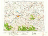
1954 Map of Great Falls
USGS Topo · Published 1964About this map
The Missouri River and Sun River converge at the center of this mid-century landscape, where the urban expansion of Great Falls is defined by a dense grid of residential streets and industrial rail lines. The presence of Malmstrom Air Force Base east of the city highlights the Cold War-era military footprint in the region, while the Great Northern and Milwaukee St Paul and Pacific railroads crisscross the plains to connect agriculture-heavy settlements like Fort Benton and Fairfield. To the north, the Benton Lake National Wildlife Refuge preserves a critical wetland system amidst the high-plains benches. Further south and east, the elevation rises sharply into the Lewis and Clark National Forest and the Highwood Mountains, where landmarks like the Tiger Butte Community Center and Running Wolf Ranger Station anchor the rural mountain communities.
Find a feature on this map
125 named features on this map. Tap any name to fly to it.
Don’t see what you’re looking for? This feature index may not catch every label — zoom into the map to look around manually.
Map Details
Editions of this 1954 Great Falls Map
4 editions found

Other maps of this area

1886 · Great Falls
USGS Topo · 1:250,000

1886 · Fort Logan
USGS Topo · 1:250,000

1886 · Little Belt Mts.
USGS Topo · 1:250,000

1889 · Big Snowy Mountain
USGS Topo · 1:250,000

1889 · Helena
USGS Topo · 1:250,000

1890 · Fort Benton
USGS Topo · 1:250,000

1892 · Fort Benton
USGS Topo · 1:250,000

1893 · Helena
USGS Topo · 1:250,000

1893 · Big Snowy Mountain
USGS Topo · 1:250,000

1894 · Little Belt Mts.
USGS Topo · 1:250,000