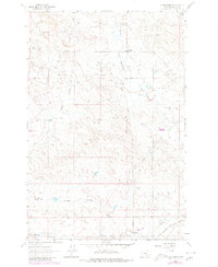
1962 Map of Grebe Ranch
USGS Topo · Published 1980About this map
Industrial development and ranching history converge in this remote corner of Rosebud County, where the Stensvad Oil Field and Northwest Sumatra Oil Field define the high plains landscape. Numerous drill holes and a prominent Pipeline network trace the mid-century expansion of Montana's petroleum industry across the prairie. Evidence of local community life persists at the Rattlesnake Sch near the banks of Rattlesnake Creek, serving the families of outlying homesteads like the Grebe Ranch.
Find a feature on this map
17 named features on this map. Tap any name to fly to it.
Don’t see what you’re looking for? This feature index may not catch every label — zoom into the map to look around manually.
Map Details
Editions of this 1962 Grebe Ranch Map
2 editions found
Other maps of this area

1954 · Forsyth
USGS Topo · 1:250,000

1957 · Forsyth
USGS Topo · 1:250,000

1958 · Forsyth
USGS Topo · 1:250,000

1962 · Guthridge Ranch
USGS Topo · 1:24,000

1962 · Melstone NE
USGS Topo · 1:24,000

1962 · Sumatra
USGS Topo · 1:24,000

1962 · Kincheloe Ranch
USGS Topo · 1:24,000

1962 · Mosby SE
USGS Topo · 1:24,000

1962 · Grebe Ranch
USGS Topo · 1:24,000

1963 · Hecker Ranch
USGS Topo · 1:24,000