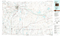
1982 Map of Greeley
USGS Topo · Published 1983About this map
The South Platte River and Cache la Poudre River converge near Greeley, anchoring a landscape defined by extensive irrigation and energy extraction. This 1982 map illustrates the complex water management system of the northern Front Range, featuring numerous storage sites like Lower Latham Reservoir, Milton Reservoir, and Fossil Creek Reservoir that support the region's agricultural base. To the southwest, the Spindle Oil Field and scattered coal operations such as the Buddy Mine and Imperial Mine highlight the industrial footprint of the era.
Find a feature on this map
124 named features on this map. Tap any name to fly to it.
Don’t see what you’re looking for? This feature index may not catch every label — zoom into the map to look around manually.
Map Details
Editions of this 1982 Greeley Map
This is the sole edition of this map. No revisions or reprints were ever made.
Other maps of this area

1890 · East Denver
USGS Topo · 1:125,000

1899 · West Denver
USGS Topo · 1:125,000

1902 · Greeley
USGS Topo · 1:125,000

1904 · Niwot
USGS Topo · 1:62,500

1906 · Loveland
USGS Topo · 1:62,500

1906 · Fort Collins
USGS Topo · 1:62,500

1907 · Livermore
USGS Topo · 1:125,000

1908 · Loveland
USGS Topo · 1:62,500

1908 · Fort Collins
USGS Topo · 1:62,500

1908 · Eaton
USGS Topo · 1:125,000