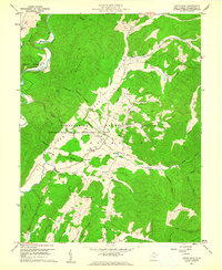
1960 Map of Green Bank
USGS Topo · Published 1961About this map
The Monongahela National Radio Astronomy Observatory occupies a central role in this Pocahontas County landscape, its Observatory Reservation Boundary and several large Telescope sites and Antenna locations defining the valley. Situated in Deer Valley between Laurel Mountain and Buffalo Ridge, the area around Green Bank and Arbovale reflects a mix of scientific advancement and deep-rooted Appalachian settlement.
Find a feature on this map
57 named features on this map. Tap any name to fly to it.
Don’t see what you’re looking for? This feature index may not catch every label — zoom into the map to look around manually.
Map Details
Editions of this 1960 Green Bank Map
Other maps of this area

1889 · Beverly
USGS Topo · 1:125,000

1892 · Beverly
USGS Topo · 1:125,000

1901 · Monterey
USGS Topo · 1:125,000

1922 · Spruce Knob
USGS Topo · 1:48,000

1922 · Cass
USGS Topo · 1:48,000

1922 · Durbin
USGS Topo · 1:48,000

1924 · Cass
USGS Topo · 1:62,500

1924 · Durbin
USGS Topo · 1:62,500

1924 · Spruce Knob
USGS Topo · 1:62,500

1941 · Monterey
USGS Topo · 1:62,500