
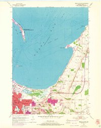
1954 Map of Green Bay East
USGS Topo · Published 1956About this map
The shoreline of Green Bay during the mid-1950s reveals a landscape of expanding coastal settlements and industrial infrastructure. Along the eastern edge of the bay, the finger of Long Tail Point reaches south into the water, sheltering Dead Horse Bay and housing an Lighthouse (Abandoned) within the Long Tail Point National Wildlife Refuge. Further south, Grassy Island and various Dumping Grounds mark the nautical approaches to the city.
Find a feature on this map
45 named features on this map. Tap any name to fly to it.
Don’t see what you’re looking for? This feature index may not catch every label — zoom into the map to look around manually.
Map Details
Editions of this 1954 Green Bay East Map
2 editions found
Other maps of this area

1954 · De Pere
USGS Topo · 1:62,500

1954 · Green Bay West
USGS Topo · 1:24,000

1954 · Denmark
USGS Topo · 1:62,500

1954 · De Pere
USGS Topo · 1:24,000

1954 · New Franken
USGS Topo · 1:62,500

1954 · Manitowoc
USGS Topo · 1:250,000

1954 · Bellevue
USGS Topo · 1:24,000

1954 · Green Bay
USGS Topo · 1:62,500

1955 · Green Bay
USGS Topo · 1:250,000

1958 · Manitowoc
USGS Topo · 1:250,000