
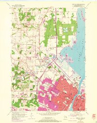
1954 Map of Green Bay West
USGS Topo · Published 1956About this map
The Fox River and Green Bay waterfront anchor this mid-century industrial and residential landscape, showing the city's growth westward into the townships of Howard and Hobart. A dense network of schools, such as West High Sch and Annunciation Sch, alongside neighborhood parks like Fisk Park and Pamperin Park, reflect the post-war expansion of the urban core. The rail infrastructure is prominent, with the Chicago and North Western and Chicago Milwaukee St Paul and Pacific lines cutting through the terrain to serve the heavy industry along the river, marked by Oil Tanks, Gas Tanks, and a Power Plant. Beyond the city limits, the map transitions into more rural areas featuring landmarks like Burden Hill and the long, thin stretch of Long Tail Point reaching into the bay, while smaller settlements like Duck Creek and Elm Tree Corners maintain their own distinct identities amid the developing suburbs.
Find a feature on this map
71 named features on this map. Tap any name to fly to it.
Don’t see what you’re looking for? This feature index may not catch every label — zoom into the map to look around manually.
Map Details
Editions of this 1954 Green Bay West Map
2 editions found
Other maps of this area

1954 · De Pere
USGS Topo · 1:62,500

1954 · Denmark
USGS Topo · 1:62,500

1954 · De Pere
USGS Topo · 1:24,000

1954 · New Franken
USGS Topo · 1:62,500

1954 · Green Bay East
USGS Topo · 1:24,000

1954 · Manitowoc
USGS Topo · 1:250,000

1954 · Bellevue
USGS Topo · 1:24,000

1954 · Green Bay
USGS Topo · 1:62,500

1955 · Green Bay
USGS Topo · 1:250,000

1958 · Manitowoc
USGS Topo · 1:250,000