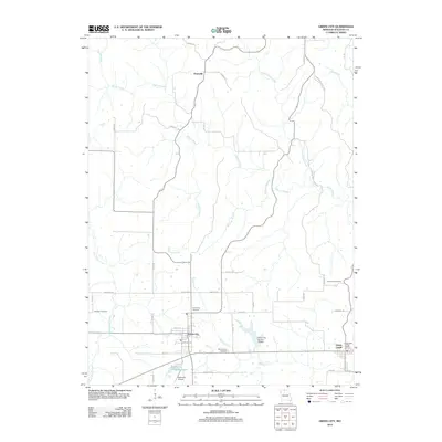
2012 Map of Green City
USGS Topo · Published 2012About this map
Green City and the neighboring community of Green Castle anchor this 2012 survey of the Sullivan County landscape. The area is defined by the headwaters of several key tributaries, including Mussel Fork and Spring Creek, which drain the rolling agricultural lands and the Union Ridge State Frst. The settlement pattern follows a grid of local roads like Memphis Rd and Midland Rd, connecting dispersed homesteads and rural cemeteries such as Hawkeye Cemetery and Mount Olive Cemetery.
Find a feature on this map
45 named features on this map. Tap any name to fly to it.
Don’t see what you’re looking for? This feature index may not catch every label — zoom into the map to look around manually.
Map Details
Editions of this 2012 Green City Map
This is the sole edition of this map. No revisions or reprints were ever made.
Other maps of this area

1912 · Green City
USGS Topo · 1:62,500

1914 · Green City
USGS Topo · 1:62,500

1954 · Centerville
USGS Topo · 1:250,000

1957 · Centerville
USGS Topo · 1:250,000

1958 · Centerville
USGS Topo · 1:250,000

1963 · Pure Air
USGS Topo · 1:24,000
1963 · Mystic
USGS Topo · 1:24,000
1964 · Milan East
USGS Topo · 1:24,000

1964 · Unionville West
USGS Topo · 1:24,000
1964 · Pollock
USGS Topo · 1:24,000