
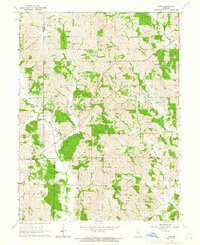
1963 Map of Pure Air
USGS Topo · Published 1964About this map
Pure Air serves as the central community on this rural landscape at the edge of the Sullivan and Adair County line. The terrain is defined by the winding paths of Spring Creek and Little Mussel Creek, which carve through the townships of Morrow, Union, and Liberty. This mid-century survey illustrates a classic Missouri agrarian pattern where small family cemeteries are the primary landmarks across the rolling acreage. Genealogists and local historians can find the locations of Daniels Cem, Campbell Cem, and Ringo Point Cem, each strategically placed near former homesteads and the drainage basins of Billy Creek and Hog Creek. The map provides a precise look at the township and range boundaries that structured local land ownership during this era.
Find a feature on this map
13 named features on this map. Tap any name to fly to it.
Don’t see what you’re looking for? This feature index may not catch every label — zoom into the map to look around manually.
Map Details
Editions of this 1963 Pure Air Map
This is the sole edition of this map. No revisions or reprints were ever made.
Other maps of this area

1911 · Queen City
USGS Topo · 1:62,500

1912 · Green City
USGS Topo · 1:62,500

1913 · Queen City
USGS Topo · 1:62,500

1914 · Green City
USGS Topo · 1:62,500

1938 · Kirksville
USGS Topo · 1:62,500

1940 · Kirksville
USGS Topo · 1:62,500

1954 · Centerville
USGS Topo · 1:250,000

1957 · Centerville
USGS Topo · 1:250,000

1958 · Centerville
USGS Topo · 1:250,000
1963 · Nind
USGS Topo · 1:24,000