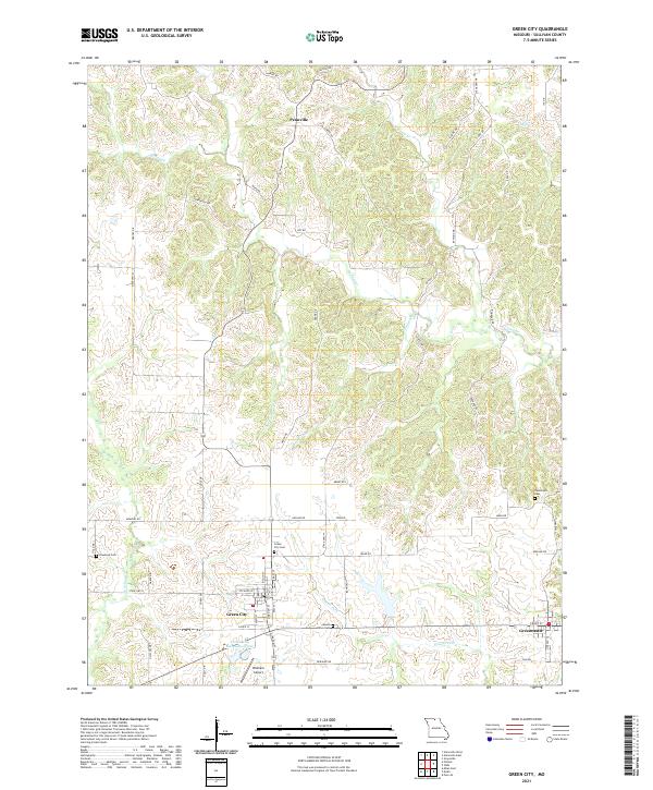
2021 Map of Green City
USGS Topo · Published 2021About this map
The Green City and Greencastle communities anchor the southern half of this Sullivan County landscape, a region defined by the intricate drainage systems of Mussel Fork and several smaller tributaries. In the north, the small settlement of Pennville sits along a ridgeline, connected by a network of rural routes including State Hwy AB and Juniper Rd. For genealogists and local historians, several burial sites are documented across the terrain, from Green City Cem and Mount Olive Cem near the town centers to the more isolated Hawkeye Cem and Overstreet Cem. This 2021 survey shows a blend of agricultural utility and modern infrastructure, featuring the Green City Large Reservoir and Widmark Airport. The topography is shaped by the winding paths of Spring Cr and W Yellow Cr, which carve through the plateau and dictate the placement of local roads and farmsteads.
Find a feature on this map
57 named features on this map. Tap any name to fly to it.
Don’t see what you’re looking for? This feature index may not catch every label — zoom into the map to look around manually.
Map Details
Editions of this 2021 Green City Map
This is the sole edition of this map. No revisions or reprints were ever made.
Other maps of this area

1912 · Green City
USGS Topo · 1:62,500

1914 · Green City
USGS Topo · 1:62,500

1954 · Centerville
USGS Topo · 1:250,000

1957 · Centerville
USGS Topo · 1:250,000

1958 · Centerville
USGS Topo · 1:250,000

1963 · Pure Air
USGS Topo · 1:24,000
1963 · Mystic
USGS Topo · 1:24,000
1964 · Milan East
USGS Topo · 1:24,000

1964 · Unionville West
USGS Topo · 1:24,000
1964 · Pollock
USGS Topo · 1:24,000