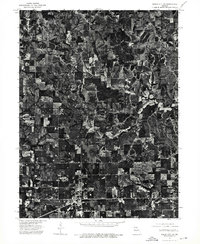
1974 Map of Green City SW
USGS Topo · Published 1976About this map
Green City and Green Castle sit at the southern edge of this mid-1970s orthophotoquad, showing the Missouri landscape during a period of transition in agricultural land management. Unlike traditional topographic maps, this aerial perspective reveals the exact texture of the Missouri hills, contrasting the tight grid of the town blocks with the irregular, branching patterns of wooded draws and clear-cut fields. The arrangement of farmsteads and field boundaries provides a clear look at rural life in Sullivan County, showing how the local topography dictated the placement of roads and homesteads. Researchers can see the density of forest cover and the precise layout of the two settlements as they appeared decades ago, offering a literal photographic record of the land before modern developments changed the rural character of the region.
Find a feature on this map
2 named features on this map. Tap any name to fly to it.
Don’t see what you’re looking for? This feature index may not catch every label — zoom into the map to look around manually.
Map Details
Editions of this 1974 Green City SW Map
This is the sole edition of this map. No revisions or reprints were ever made.
Other maps of this area

1912 · Green City
USGS Topo · 1:62,500

1914 · Green City
USGS Topo · 1:62,500

1954 · Centerville
USGS Topo · 1:250,000

1957 · Centerville
USGS Topo · 1:250,000

1958 · Centerville
USGS Topo · 1:250,000

1963 · Pure Air
USGS Topo · 1:24,000
1963 · Mystic
USGS Topo · 1:24,000
1964 · Milan East
USGS Topo · 1:24,000

1964 · Unionville West
USGS Topo · 1:24,000
1964 · Pollock
USGS Topo · 1:24,000