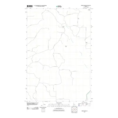
2010 Map of Green Knob
USGS Topo · Published 2010About this map
Green Knob rises above a rural Idaho landscape defined by the winding course of Little Potlatch Creek and the deeper drainages leading toward the Potlatch River. This 2010 topographic survey documents a network of rural roads and ridge-top land use that reflects generations of ranching and agricultural history in Nez Perce County. Notable landmarks for genealogical research include the Overacker Cemetery, situated along the Genesee-Julietta Rd, and the Fix Ridge Cemetery to the east. The map provides a detailed look at the local geography where the high ground of Fix Ridge meets the steep descent of Bethel Canyon. The pattern of property access via routes like Gray Eagle Rd and Magee Rd illustrates the enduring layout of rural homesteads and land divisions established decades earlier.
Find a feature on this map
31 named features on this map. Tap any name to fly to it.
Don’t see what you’re looking for? This feature index may not catch every label — zoom into the map to look around manually.
Map Details
Editions of this 2010 Green Knob Map
This is the sole edition of this map. No revisions or reprints were ever made.
Other maps of this area

1955 · Pullman
USGS Topo · 1:250,000

1958 · Pullman
USGS Topo · 1:250,000

1958 · Lapwai
USGS Topo · 1:24,000

1958 · Lewiston Orchards North
USGS Topo · 1:24,000

1958 · Lewiston Orchards
USGS Topo · 1:62,500

1958 · Culdesac
USGS Topo · 1:62,500

1960 · Troy
USGS Topo · 1:24,000

1960 · Moscow East
USGS Topo · 1:24,000

1961 · Kendrick
USGS Topo · 1:62,500

1961 · Moscow
USGS Topo · 1:62,500