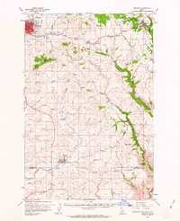
1961 Map of Moscow
USGS Topo · Published 1963About this map
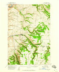
Moscow and Genesee anchor this early 1960s study of the Latah County plateau, where the Northern Pacific railroad winds through a landscape of rolling wheat country and deeply incised creek canyons. The map illustrates the region's rural social infrastructure, noting landmarks like the Aspendale Community Hall and several family-named burial grounds including Buchanan Cem and Overacker Cem. The terrain transitions from the developed streets of the county seat toward the timbered slopes of Paradise Ridge and Driscoll Ridge. Beyond the primary settlements, small rail stops and communities like Joel, Cornwall, and Troy are documented along the tracks. Significant topographic features like Tomer Butte and Green Knob provide vertical relief against the winding courses of Little Potlatch Creek and the South Fork of the Palouse River, while the southern boundary reaches the Indian Reservation Boundary near Catholic Creek.
Find a feature on this map
37 named features on this map. Tap any name to fly to it.
Don’t see what you’re looking for? This feature index may not catch every label — zoom into the map to look around manually.
Map Details
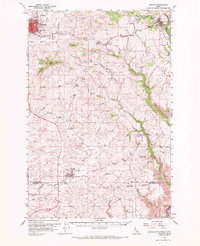
Editions of this 1961 Moscow Map
2 editions found
Other maps of this area

1910 · Pullman
USGS Topo · 1:125,000

1945 · Clarkston
USGS Topo · 1:62,500

1948 · Clarkston
USGS Topo · 1:62,500

1955 · Pullman
USGS Topo · 1:250,000

1958 · Pullman
USGS Topo · 1:250,000
1958 · Lapwai
USGS Topo · 1:24,000
1958 · Lewiston Orchards North
USGS Topo · 1:24,000

1958 · Lewiston Orchards
USGS Topo · 1:62,500
1958 · Culdesac
USGS Topo · 1:62,500
1960 · Troy
USGS Topo · 1:24,000