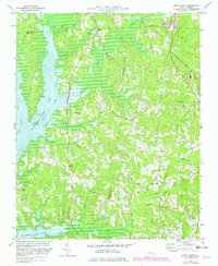
1973 Map of Green Level
USGS Topo · Published 1982About this map
B Everett Jordan Lake dominates the western landscape of this North Carolina survey, its waters reaching into the valleys of Morgan Creek and Little New Hope Creek. The map documents a rural transition as the reservoir changed the local topography, yet legacy landmarks remain visible across the rolling hills. Numerous country churches, including Marthas Chapel and Mt Pisgah Ch, serve as anchors for the scattered rural communities. To the east, the Norfolk and Southern railroad corridor passes through Genlee, while an Old Railroad Trail further west hints at earlier transportation routes. The convergence of Durham, Chatham, and Wake counties meets here, marking a region defined by its numerous small waterways like Panther Creek and White Oak Creek that drain toward the new lake.
Find a feature on this map
39 named features on this map. Tap any name to fly to it.
Don’t see what you’re looking for? This feature index may not catch every label — zoom into the map to look around manually.
Map Details
Editions of this 1973 Green Level Map
2 editions found
Other maps of this area

1943 · Durham South
USGS Topo · 1:62,500

1946 · Chapel Hill
USGS Topo · 1:24,000

1947 · Chapel Hill
USGS Topo · 1:31,680

1951 · Farrington
USGS Topo · 1:24,000

1951 · Durham South
USGS Topo · 1:62,500

1953 · Raleigh
USGS Topo · 1:250,000

1954 · Raleigh
USGS Topo · 1:250,000

1969 · New Hope Dam
USGS Topo · 1:24,000
1973 · Cary
USGS Topo · 1:24,000
1973 · Green Level
USGS Topo · 1:24,000