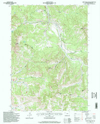
1996 Map of Green Mountain
USGS Topo · Published 1998About this map
Green Mountain and Grouse Mountain anchor this high-altitude landscape in the mid-1990s, where the management of the Teton National Forest is defined by the Buffalo Jackson Ranger District. The terrain is shaped by a dense network of drainages, including the South Fork Spread Creek and Leidy Creek, which flow through steep valleys marked by occasional 4wd tracks. Human presence in this wilderness is minimal, centered around specialized outposts such as Cow Camp and a Corral located near the confluence of Little Bear Creek and Bear Creek. Small, high-country water bodies like Hidden Lake and Leidy Lake are tucked into the drainages of East Leidy Creek, illustrating a landscape primarily dedicated to resource management and seasonal livestock grazing rather than permanent settlement. The presence of a Drill Hole and a Repeater Link suggests the limited but vital industrial and communication infrastructure necessary for this high-country environment.
Find a feature on this map
28 named features on this map. Tap any name to fly to it.
Don’t see what you’re looking for? This feature index may not catch every label — zoom into the map to look around manually.
Map Details
Editions of this 1996 Green Mountain Map
This is the sole edition of this map. No revisions or reprints were ever made.
Other maps of this area

1902 · Mt Leidy
USGS Topo · 1:125,000

1955 · Driggs
USGS Topo · 1:250,000

1958 · Driggs
USGS Topo · 1:250,000

1962 · Driggs
USGS Topo · 1:250,000

1965 · Davis Hill
USGS Topo · 1:24,000

1965 · Green Mountain
USGS Topo · 1:24,000

1965 · Rosies Ridge
USGS Topo · 1:24,000

1965 · Mount Leidy
USGS Topo · 1:24,000
1965 · Upper Slide Lake
USGS Topo · 1:24,000

1965 · Tripod Peak
USGS Topo · 1:24,000