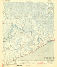
1944 Map of Green Point
USGS Topo · Published 1944About this map
Tates Hell Swamp dominates the upper half of this coastal interior, revealing a complex network of wetlands and drainage patterns during the mid-1940s. The landscape is defined by its transition from the dense swamp to the shoreline of St George Sound, where small settlements like Green Point and High Bluff are situated. An abandoned RR grade and an abandoned grade cut through the upper sections, indicating a period of early 20th-century logging or infrastructure that had already receded by the time of the 1943 survey. Along the southern coast, Porters Bar Cem and landforms like Marsh Point and Royal Bluff offer specific points of interest for local historians and genealogists. The intricate waterways, including Cash Bayou and East Bayou, illustrate the tidally influenced geography that shaped early transportation and habitation in this part of Franklin County.
Find a feature on this map
34 named features on this map. Tap any name to fly to it.
Don’t see what you’re looking for? This feature index may not catch every label — zoom into the map to look around manually.
Map Details
Editions of this 1944 Green Point Map
4 editions found
Other maps of this area

1943 · Apalachicola
USGS Topo · 1:31,680

1943 · Carrabelle
USGS Topo · 1:24,000

1944 · Pickett Bay
USGS Topo · 1:31,680

1944 · Carrabelle
USGS Topo · 1:31,680

1944 · Green Point
USGS Topo · 1:31,680

1944 · Sugar Hill
USGS Topo · 1:31,680

1944 · Apalachicola
USGS Topo · 1:24,000

1945 · Tates Hell Swamp
USGS Topo · 1:31,680

1945 · Sugar Hill
USGS Topo · 1:31,680

1945 · Beverly
USGS Topo · 1:31,680