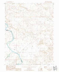
1988 Map of Green River SE
USGS Topo · Published 1988About this map
The confluence of the San Rafael River and the Green River defines the landscape of this southeastern Utah region during the late 1980s. Following the border between Grand Co and Emery Co, the terrain is marked by a network of drainage systems including Salt Wash, White Wash, and Red Wash. Human activity is concentrated around Ruby Ranch, which stands as the primary named settlement in this arid environment. Industrial exploration is evident through scattered infrastructure, including an Oil Well and several Tanks. The presence of a Mine near the riverbanks and a Quarry further inland suggests a reliance on natural resource extraction. This provisional survey captures the transition of the desert landscape just before modern digital mapping, preserving the locations of remote outposts and infrastructure in a period of ongoing mineral and ranching activity.
Find a feature on this map
12 named features on this map. Tap any name to fly to it.
Don’t see what you’re looking for? This feature index may not catch every label — zoom into the map to look around manually.
Map Details
Editions of this 1988 Green River SE Map
This is the sole edition of this map. No revisions or reprints were ever made.
Other maps of this area

1885 · San Rafael
USGS Topo · 1:250,000

1885 · La Sal
USGS Topo · 1:250,000

1951 · The Knoll
USGS Topo · 1:62,500

1952 · Tidwell 4 NE
USGS Topo · 1:24,000

1952 · Moab 3 NW
USGS Topo · 1:24,000

1954 · Tidwell 1 NE
USGS Topo · 1:24,000

1954 · Tidwell 1 SW
USGS Topo · 1:24,000

1954 · Tidwell 1 NW
USGS Topo · 1:24,000

1954 · Tidwell 1 SE
USGS Topo · 1:24,000

1954 · Green River
USGS Topo · 1:62,500