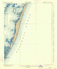
1901 Map of Green Run
USGS Topo · Published 1934About this map
The Life-Saving Service (L.S.S.) stations of the Maryland-Virginia coastline provide a critical look at early maritime safety along this exposed barrier island stretch. At the turn of the century, these manned outposts, including North Beach L.S.S., Green Run Inlet L.S.S., and Pope Island L.S.S., were the primary defense against the shipwrecks common to the Atlantic Ocean coast.
Find a feature on this map
37 named features on this map. Tap any name to fly to it.
Don’t see what you’re looking for? This feature index may not catch every label — zoom into the map to look around manually.
Map Details
Editions of this 1901 Green Run Map
4 editions found
Other maps of this area

1901 · Snow Hill
USGS Topo · 1:62,500

1901 · Green Run
USGS Topo · 1:62,500

1901 · Ocean City
USGS Topo · 1:62,500

1902 · Pittsville
USGS Topo · 1:62,500

1938 · Green Run
USGS Topo · 1:62,500

1942 · Ocean City
USGS Topo · 1:62,500

1942 · Chincoteague East
USGS Topo · 1:24,000

1942 · Ninepin
USGS Topo · 1:24,000

1942 · Ocean City
USGS Topo · 1:24,000

1942 · Tingles Island
USGS Topo · 1:24,000