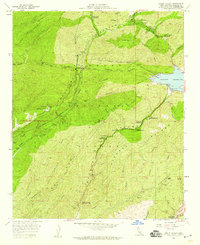
1958 Map of Green Valley
USGS Topo · Published 1959About this map
The Sierra Pelona range dominates this landscape in the late 1950s, defining a region where critical water infrastructure meets the steep canyons of northern Los Angeles County. The Los Angeles Aqueduct Tunnel cuts through the mountains, leading toward the San Francisquito Powerhouse No 2 and the Bouquet Reservoir. This complex engineering network is contrasted by the numerous campgrounds, such as South Portal Campground and Bouquet Campground No 3, which serve the recreational needs of the era. Settlement is concentrated in Green Valley, while the surrounding terrain is marked by fire suppression and resource extraction. Evidence of earlier industry persists at the Silver King Mine and California Mine, alongside the Texas Canyon Fire Control Sta and various lookout points like Jupiter Mountain. The map reveals a land management pattern of firebreaks and truck trails like the Del Sur Truck Trail.
Find a feature on this map
51 named features on this map. Tap any name to fly to it.
Don’t see what you’re looking for? This feature index may not catch every label — zoom into the map to look around manually.
Map Details
Editions of this 1958 Green Valley Map
3 editions found
Other maps of this area

1900 · Fernando
USGS Topo · 1:62,500

1901 · Southern California Sheet No. 1
USGS Topo · 1:250,000

1903 · Tejon
USGS Topo · 1:125,000

1903 · Camulos
USGS Topo · 1:125,000

1903 · Santa Susana
USGS Topo · 1:62,500

1904 · Southern California Sheet No. 1
USGS Topo · 1:250,000

1915 · Elizabeth Lake
USGS Topo · 1:125,000

1917 · Elizabeth Lake
USGS Topo · 1:125,000

1929 · Saugus
USGS Topo · 1:24,000

1929 · Lang
USGS Topo · 1:24,000