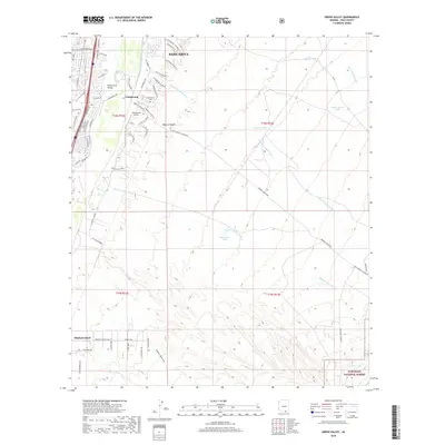
2018 Map of Green Valley
USGS Topo · Published 2018About this map
Sahuarita and the community of Continental anchor this study of the Santa Cruz River valley south of Tucson. The map details a transition from the suburban residential corridors along the Santa Cruz River to the high desert terrain of the Coronado National Forest. Modern developments like Santa Cruz Valley are shown alongside historical landmarks including the Continental Cem and the Continental Airport. The topography is defined by complex drainage systems, with numerous ephemeral waterways such as Sawmill Canyon Wash and Florida Canyon Wash carving through the landscape. In the arid southern section, essential water management is evident through named stock tanks like Horseshoe Tank and Juniper Tank, while the prominent landform of Elephant Head marks the approach to the higher elevations. This document reflects the contemporary intersection of residential growth and the conserved desert environment of Pima County.
Find a feature on this map
69 named features on this map. Tap any name to fly to it.
Don’t see what you’re looking for? This feature index may not catch every label — zoom into the map to look around manually.
Map Details
Editions of this 2018 Green Valley Map
This is the sole edition of this map. No revisions or reprints were ever made.
Other maps of this area
1904 · Patagonia
USGS Topo · 1:125,000
1905 · Patagonia
USGS Topo · 1:125,000
1920 · Arivaca
USGS Topo · 1:125,000
1922 · Agus Caliente
USGS Topo · 1:62,500
1925 · Samaniego Peak
USGS Topo · 1:62,500
1926 · Helvetia
USGS Topo · 1:62,500
1939 · Twin Buttes
USGS Topo · 1:62,500
1939 · Tubac
USGS Topo · 1:62,500
1941 · Twin Buttes
USGS Topo · 1:62,500
1943 · Tubac
USGS Topo · 1:62,500