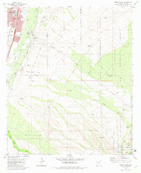
1981 Map of Green Valley
USGS Topo · Published 1982About this map
The Santa Cruz River valley near the turn of the 1980s displays a landscape defined by the proximity of the growing Green Valley residential area and the agricultural and transit hub at Continental. While residential development and a Golf Course characterize the northwest, the map records the vital infrastructure of the era, including the Southern Pacific railroad and a Landing Strip. The eastern half of the sheet is dominated by the Santa Rita Experimental Range and Wildlife Area, where numerous drainage features like Sawmill Canyon Wash and Florida Canyon Wash descend toward the valley. This survey captures a moment when the rural character of the Grant Boundary area remained distinct from the intensifying suburban footprint, marked by scattered local landmarks such as the Continental Sch, a Cem, and various stock tanks like Kinney Tank and Horseshoe Tank.
Find a feature on this map
35 named features on this map. Tap any name to fly to it.
Don’t see what you’re looking for? This feature index may not catch every label — zoom into the map to look around manually.
Map Details
Editions of this 1981 Green Valley Map
This is the sole edition of this map. No revisions or reprints were ever made.
Other maps of this area

1904 · Patagonia
USGS Topo · 1:125,000

1905 · Patagonia
USGS Topo · 1:125,000

1920 · Arivaca
USGS Topo · 1:125,000

1922 · Agus Caliente
USGS Topo · 1:62,500

1925 · Samaniego Peak
USGS Topo · 1:62,500

1926 · Helvetia
USGS Topo · 1:62,500

1939 · Twin Buttes
USGS Topo · 1:62,500

1939 · Tubac
USGS Topo · 1:62,500

1941 · Twin Buttes
USGS Topo · 1:62,500

1943 · Tubac
USGS Topo · 1:62,500