
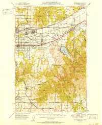
1951 Map of Greenacres
USGS Topo · Published 1951About this map
The industrial and agricultural landscape of the Spokane Valley is captured here just after the war, showing a region defined by complex rail networks and military-industrial expansion. The Naval Supply Depot and the adjacent Aluminum Rolling Mill dominate the terrain near Trentwood, signaling the area's strategic importance during and after the conflict. This development is set against a backdrop of established rural life, evidenced by many small settlements like Otis Orchards, Opportunity, and Greenacres.
Find a feature on this map
82 named features on this map. Tap any name to fly to it.
Don’t see what you’re looking for? This feature index may not catch every label — zoom into the map to look around manually.
Map Details
Editions of this 1951 Greenacres Map
2 editions found
Other maps of this area

1901 · Spokane
USGS Topo · 1:125,000

1903 · Oakesdale
USGS Topo · 1:125,000

1903 · Rathdrum
USGS Topo · 1:125,000

1905 · Oakesdale
USGS Topo · 1:125,000

1943 · Mt Spokane
USGS Topo · 1:62,500

1949 · Deer Park
USGS Topo · 1:62,500

1949 · Greenacres
USGS Topo · 1:62,500

1950 · Spokane NE
USGS Topo · 1:24,000

1950 · Spokane SE
USGS Topo · 1:24,000

1950 · Mt Spokane
USGS Topo · 1:62,500